













DISTANCE
80 km
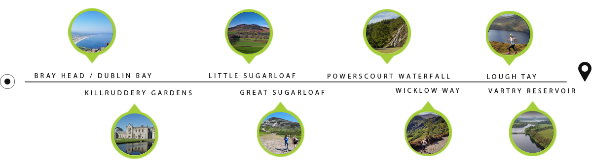











The longest race of our Irish series takes you from the coastal town of Bray to the Wicklow Mountains National Park. Your journey begins on the seaside promenade before the short, steep climb to the iconic cross on Bray Head. Here you bid farewell to your views of the Irish Sea and turn towards the mountains proper. Interesting rocky trails take you across Little and Great Sugarloaf Mountains, passing the scenic Kilruddery Estate on the way to the Wicklow Way — a 132 km walking trail stretching south from Dublin. The middle section offers nearly every type of good trail imaginable, a few quiet country roads and plenty of ups and downs. Pass Powerscourt Waterfall and the Lough Tay “Guinness Lake” viewpoint. A loop of the newly upgraded Roundwood Reservoir trails marks the start of the return journey via Belmont Estate. The seafront finish promises a true Irish welcome. We expect most finishers to arrive between 9 and 12 hours after setting out, with dusk settling over Dublin Bay and the lights of Bray and Dublin welcoming runners home. The climbs, descents and long stretches between them: explore the profile, then open the route in your preferred mapping platform. The route map is for general information, not permission to access the course. Please do not access private sections in Kilruddery and Belmont Estates or Powerscourt Waterfall unless using their permitted public access routes. Check the expected passage times, mandatory cut-offs and services along the route. Cut-off times are highlighted in yellow. Scroll sideways to see every column. “Fastest” and “Slowest” are estimated passage times; cut-offs are the mandatory limits. There are cut-off points along the course, including an option to move onto the 46 km event at Djouce Wall. Read the full cut-off and downgrade guide and speak to a marshal before changing route. Register for the morning bus from Dublin city centre. Mountains, forest trails and a finish beside the sea. 80 km eventCoast · mountains · forest
A full day of Wicklow trails.
Bray Head & the Sugarloafs
Waterfalls, lakes & forest
Roundwood to Bray
Read the terrain
Your course at a glance.
Respect private access
Know your checkpoints
Plan your progress.
Point
Altitude (M)
dist (km)
Dist. Inter (km)
Elevation gain (m)
Elevation loss (m)
Fastest
Slowest
Cut off
Services
Bray
0
0
0.0
0
0
Sat 07:30 am
Sat 07:30 am
Little Sugarloaf
154
9.4
9.4
472
262
Sat 08:17 am
Sat 09:06 am
Great Sugarloaf
294
15.3
5.9
299
216
Sat 08:44 am
Sat 10:03 am
Sat 10:30 am
WaterFoodMedical
Djouce Wall
408
24
8.7
387
277
Sat 09:27 am
Sat 11:25 am
Sat 12:00 pm
J B Malone (Lough Tay)
484
29.4
5.4
230
152
Sat 09:55 am
Sat 12:16 pm
Water
Roundwood Reservoir
229
40
10.6
192
447
Sat 10:48 am
Sat 01:59 pm
Sat 01:45 pm
WaterFood
Roundwood Reservoir 2
229
40.3
0.3
57
57
Sat 11:10 am
Sat 02:52 pm
Sat 03:00 pm
WaterFood
J B Malone (Lough Tay) 2
484
51.9
11.6
278
20
Sat 11:36 am
Sat 03:37 pm
Sat 03:45 pm
Water
Djouce Wall 2
408
57.4
5.5
152
221
Sat 12:04 am
Sat 05:17 pm
Great Sugarloaf 2
294
63.5
6.1
92
223
Sat 12:39 pm
Sat 05:34 pm
Sat 05:30 pm
WaterFoodMedical
Little Sugarloaf 2
154
69.5
6.0
162
297
Sat 01:09 pm
Sat 06:11 pm
Belmont
114
72.4
2.9
146
176
Sat 01:22 pm
Sat 07:03 pm
Sat 06:50 pm
Water
Bray
0
79.94
7.5
172
291
Sat 02:11 pm
Sat 08:20 pm
Sat 08:00 pm
WaterFoodMedical
View the original timing table
Know your cut-offs before you start
Arrive ready
Make race day simple.
Travelling from Dublin?
EcoTrail Wicklow · 80 km
Your Wicklow adventure starts here.

100K category graphic